views
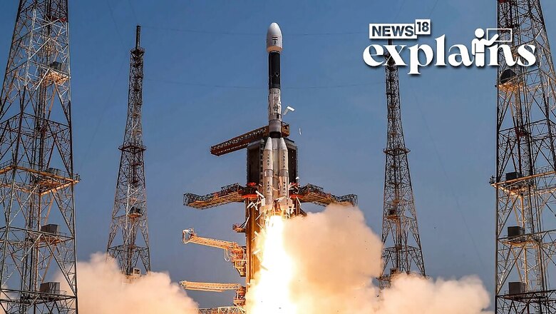
In a significant leap forward, the Indian Space Research Organisation (ISRO) successfully launched a cutting-edge navigational satellite using the GSLV rocket from Sriharikota in Andhra Pradesh. This mission aims to revolutionize positioning and timing services by providing real-time data.
The satellite, known as NVS-01, is a pioneering addition to the second generation of satellites envisioned for the Navigation with Indian Constellation (NavIC) services. Its primary objective is to deliver precise positioning and timing information across India and an expansive region extending approximately 1,500 km from the mainland.
With the NVS series of satellites, ISRO plans to not only bolster the existing NavIC system but also introduce advanced features that enhance its capabilities. This launch sets the stage for a new era of satellite-based navigation in India, unlocking a host of applications and benefits for various sectors.
#WATCH | Indian Space Research Organisation (ISRO), launches its advanced navigation satellite GSLV-F12 and NVS-01 from Sriharikota.(Video: ISRO) pic.twitter.com/2ylZ8giW8U
— ANI (@ANI) May 29, 2023
ISRO’s visionary approach and successful deployment of NVS-01 marks a significant milestone in India’s pursuit of self-reliance in the field of navigation technology. As the nation embraces this cutting-edge satellite, it sets the foundation for a more accurate, efficient, and robust positioning and timing system that caters to the diverse needs of India and its neighboring regions.
Mission Launched
The Geosynchronous Satellite Launch Vehicle (GSLV) embarked on its 15th mission, carrying the NVS-01 navigation satellite weighing 2,232 kg. Standing tall at 51.7 meters, the GSLV propelled the satellite into space, as per reports.
After a precise 19-minute flight, the NVS-01 satellite was accurately placed in a Geosynchronous Transfer Orbit. In the upcoming phases, planned orbit-raising maneuvers will guide NVS-01 into its intended Geosynchronous orbit, as confirmed by ISRO.
Approximately 20 minutes into the flight, the rocket is scheduled to release the satellite into a geosynchronous transfer orbit (GTO) at an altitude of around 251 km, according to ISRO’s statement.
The NVS-01 satellite is equipped with navigation payloads in L1, L5, and S bands. Notably, this second-generation satellite series boasts an indigenously developed Rubidium atomic clock, setting it apart from its predecessors.
NavIC Series
The NavIC series of satellites heralds a new era of navigation, offering a multitude of features that encompass terrestrial, aerial, and maritime domains. From precision agriculture to location-based services on mobile devices and even marine fisheries, the NavIC system opens up a wide array of possibilities for various sectors.
Notably, this mission marks the sixth operational flight of the GSLV with an indigenous cryogenic stage, showcasing India’s self-reliance in space technology. With the successful launch of NVS-01, ISRO anticipates a mission life exceeding 12 years for the satellite, further reinforcing its longevity and durability.
More About the Navigational Satellite Series
NavIC, also known as the Indian Regional Navigation Satellite System (IRNSS), is a sophisticated navigation system consisting of a constellation of seven satellites and a network of ground stations that operate continuously. Originally, there were eight satellites, but currently, seven satellites remain active in the system, as per reports. The constellation comprises three satellites in geostationary orbit and four satellites in geosynchronous orbit.
The development of NavIC began with the launch of the first satellite, IRNSS-1A, on July 1, 2013, and concluded with the launch of the eighth satellite, IRNSS-1I, in April 2018. In 2016, during the seventh satellite launch (IRNSS-1G), India’s Prime Minister renamed the system as NavIC.
NavIC has gained international recognition and was acknowledged by the International Maritime Organization (IMO) as part of the World-Wide Radio Navigation System (WWRNS) for operations in the Indian Ocean Region in 2020.
The system’s capabilities encompass a wide range of applications, including terrestrial, aerial, and marine navigation. It can aid in disaster management, vehicle tracking, and fleet management, particularly in industries such as mining and transportation. NavIC can also be integrated with mobile phones, enabling enhanced navigation services. Moreover, it provides precise timing, essential for applications like ATMs and power grids, as well as facilitating mapping and geodetic data collection.
NavIC represents India’s significant advancement in satellite navigation technology, empowering various sectors with reliable positioning, timing, and navigation services. Its extensive capabilities make it a versatile tool with immense potential for diverse applications.
What’s Special About the Second Generation?
The second-generation NavIC satellite, represented by the NVS-01 in ISRO’s NVS series, introduces several notable advancements, as per a report by the Indian Express.
One significant technological upgrade is the inclusion of a Rubidium atomic clock onboard the satellite. This indigenously developed space-qualified clock is a remarkable achievement for India. Rubidium atomic clocks are highly precise timekeeping devices utilized by only a few countries worldwide.
The second-generation satellites will transmit signals in a third frequency, L1, in addition to the L5 and S frequency signals already provided by the existing satellites. This expansion of frequencies enhances interoperability with other satellite-based navigation systems.
By incorporating L1 frequency signals, the second-generation NavIC satellites enable improved utilization of the regional navigation system in wearable devices. Wearable devices and personal trackers equipped with low-power, single-frequency chips can effectively leverage the L1 frequency, expanding the range of applications for NavIC in consumer devices.
With inputs from agencies


Comments
0 comment