views
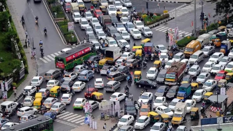
Amid the criticism over traffic snarls, the Bengaluru Traffic Police are aiming for data-driven traffic management to handle the Outer Ring Road (ORR), according to MN Anucheth, Joint Commissioner of Police (JCP), Traffic.
From data from aggregators to the number of carks parked in the lot as of 2 pm every single day, the information is used to check if the area will see traffic congestion beyond the baseline model.
“In that case, we take decisions such as prohibiting heavy goods vehicles from plying on that stretch or staggered exit of vehicles. Each tech park has their own staggered exit plan…With data sources, over the next four to five months, we can also get into predictive mapping," he said.
Edited excerpts from the interview:
You are using AI and drones to collate data on traffic congestion in Bengaluru. How does this work?
In Bengaluru, we are aiming for data-driven traffic management. We have large sources of data in the city and we are collaborating with other sources as well. We get data from multiple sources such as our 8,000 safe city cameras, 4,000 strong force on ground, which gives us real-time updates on road conditions, including waterlogging, vehicle offload, tree falling or accidents. We also collect data from map-based sources, mobility aggregators and drones. We get a bird’s eye view on corridors. The idea is to ensure that we move towards congestion management with the available resources. We can’t change the roads, it’s a long-term plan, so this will help us get real-time solutions. This will also feed into the new signalling system and increase the speed in the city as well reduce the time at traffic junctions. We are also trying to get an AI-based congestion alerts. The idea is to get the information of the problem even before people tell us.
You have a major choke point called the Outer Ring Road…
For the Outer Ring Road, we are collecting data from aggregators. We get information beforehand on the bookings of taxis or vehicles from ORRCA. We get accurate data on how many cars are parked in the lot park as of 2 pm every single day. This information is crowdsourced. If we see that there is a baseline model beyond which traffic congestion is occurring, we take decisions such as prohibiting heavy goods vehicles form plying on that stretch or staggered exit of vehicles. Each tech park has their own staggered exit plan, we advise them to use it based on our AI-based information. With data sources, over the next four to five months, we can also get into predictive mapping.
Traffic plans are changed daily based on updates. What patterns have you have been seeing?
We are collecting data on vehicular flow and traffic congestion in Bengaluru. Certain corridors such as the Outer Ring Road corridor between Silk broad to Marathahalli up to Tin factory see the IT crowds. We want to understand traffic flows in the morning and evening and what contributes to choking. We get data down to the corridor level to the road where issues are occurring and work on resolving the issues.
How many drones have been deployed? What happens to the data from them?
We have 10 drones, and they have a flying time of 1.5 to 2 hours, twice a day — in the morning and evening. About four hours a day, they fly and we have identified around 20 important junctions in the city. We get a bird’s eye view, and the visuals give us a lot of information from critical junctions such as Hebbal, Sarakki, Marathahalli, Iblur, Silk Board, etc. During peak hours, we are able to find the problem and take measures quickly.
Are you saying that in case of unprecedented traffic jams for hours, the drones can fly over, find the problem area and send live visuals to resolve the issue?
That is the endgame. Probably, in the next six months, we will be in a station where the drone takes off on its own at a particular time, analyses and at the back end, the AI will gives us information on what has happened, so we can intervene physically.
Have you been able to detect issues using these images and resolve it? Any examples?
Technology is a force multiplier, it is an enhancer. It is no replacement for human work, but it really helps us in quicker detection and action. For example, the Hebbal flyover was choked unusually at 2 am on January 15. We found it was an accident that had not been reported. We were able to send the ambulance quickly and shift the person to a hospital with the help of AI. It is not just about congestion, but also about emergency services. On January 17, the NICE road was congested at 5.15am, again unusual. We found it was because a herd of elephants was crossing the road. So drones help us find the issue and the cause, with visuals for better intervention.






Comments
0 comment