
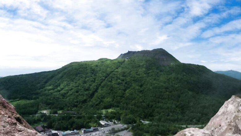
The existence of a volcanic mountain in Hokkaido was kept hidden by the Japanese government for approximately six years before it was presented at the World Volcano Conference in Osla by a local postmaster Masao Mimatsu in 1948. The mountain is named Showa Shinzan. The current peak of this volcanic lava dome is 398 metres. It is located in the Shikotsu-Toya National Park, next to Mount Usu.
The mountain was named after Emperor Showa who was also known as Hirohito during its formation. As per reports, the mountain surfaced between December 1943 to September 1945. It was born out of a wheat field after it was rapidly uplifted following the series of earthquakes at Mount Usu at the beginning of 1944.
When Showa Shinzan first appeared, the Japanese authorities were worried that it could be considered a bad omen as World War II was in full swing at the time. Due to this, they decided to conceal this fact to maintain positivity in the army camps. However, a local postmaster, Masao Mimatsu kept recording the ever-changing measurements of the mountain.
As per the records for the progress years of Mt Showa Shinzan by Masao Mimatsu, the volcanic activity of this mountain can be divided into three phases. In 1943, several earthquakes started to occur at Mt. Usu. As per reports, it suffered 200 earthquakes a day which shifted the hypocentre during that time, resulting in a protuberance emerging from the wide wheat field towards the eastern part of Mt Usu. The peak started to rise day by day.
The following year saw the first eruption. By the end of the year, Masao Mimastsu recorded a total of seven craters, 17 major eruptions and countless minor ones. At the same time, protuberance grew by two metres on some days. After the earthquake activity came to a halt, the volcanic eruptions from this mountain ceased and began to take shape until September 1945.
Masao Mimatsu bought this place by investing all his capital just for research and became its owner. Later the Japanese government declared it a natural monument and a statue of Mimatsu was also built here. The progress chart of the local postmaster is widely known as the Mimatsu Diagrams.


Comments
0 comment